Perusahaan ini terdaftar sebagai Free Member. Hindari melakukan pembayaran sebelum bertemu penjual atau melihat barang secara langsung. COD (Cash On Delivery) atau bertemu langsung dengan penjual merupakan metode transaksi aman yang kami sarankan.
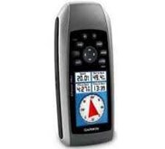
GARMIN OREGON 550 GPS MAPPING + CAMERA These high sensitivity, rugged GPS receivers bring touch screen technology to the outdoors! The 3Ý touch screen provides enhanced user interface plus the Oregon 300, 400t, 550 and 550t GPS receivers allow wireless sharing of user tracks, waypoints, routes, and geocaches, and they have software which focuses on the map screen and uses Digital Elevation Model ( DEM) Shading to enhance situational awareness. The Oregon 550 Series GPS receivers also feature a built-in camera and a 3-axis tilt-compensated compass for accurate headings even when the unit is not held in a level position! The 3.2 megapixel auto-focus camera has 4x digital zoom and automatically geotags each photo with the location where it was taken, allowing you to mark, remember, and navigate back to the exact spot in the future. Other features of all the Oregon Models include a Micro SD card slot for optional mapping and user data storage, user-configurable profiles - auto, marine, recreation, fitness and geocache, an electronic compass and barometric altimeter, and a JPG image viewer for viewing pictures from the Micro SD card. Compatible with HR monitor and GSC10. Supports www.geocaching.com GPX files and the display of detailed geocache information such as terrain, difficulty, cache descriptions and hints. Specifications Receiver Channels: 12. GPS Antenna: High Sensitivity. WAAS Capable: Yes. Acquisition Time: 0: 01 - 0: 36. Accuracy: ± 10m. DGPS: 3-5m. Waterproof Standard: IEC 60529 IPX7. Unit Size: 4.5 " x 2.3 " x 1.4 " . Unit Weight: 6.8 oz. with batteries. Display Type: Transflective Color TFT touchscreen. Display Size: 3.0 " Diagonal ( 2.6 " x 1.5 " ) . Battery: 2 AA ( included) . Battery Life ( Hours) : 16. Internal Memory: 850 MB. Expandability: Micro SD Card. USB & Serial: USB. Basemap: Routable DEM. Map Storage: Micro SD. Wireless Communication: Yes. Topographic Maps: no. Marine Maps: Optional. Area Calculation: Yes. Electronic Compass: Yes ( tilt-compensated, 3-axis) . Barometer/ Altimeter: Yes. Calendar: No. Audible Alarms: Yes. Elevation/ Vertical Speed: Yes. Camera: Yes. Tidal Information: Yes. Celestial Information: Yes.